
A powerful 7.4-magnitude quake jolted southeastern Mindanao on October 10, followed by a string of aftershocks and another quake farther south. That tremor is the latest in a spate of seismic events, coming just days after the deadly 6.9 earthquake in Cebu province.
The Philippine archipelago, perched on the restless Pacific “Ring of Fire,” has long faced earthquakes as part of daily life. In October 2025, however, seismic activity has surged. On October 10, a powerful magnitude 7.4 quake struck off the coast of Manay, Davao Oriental in Mindanao. Eleven hours later, a magnitude 6.7 tremor rattled the same fault system. Both quakes followed the September 30 magnitude 6.9 event in central Cebu, which claimed at least 75 lives.
Each shock has left scars: collapsed mines, damaged structures, shattered nerves, and renewed urgency in a region that knows too well how sudden earth’s shifts can be.
The October 10 quake struck at 9:43 a.m. local time, at a depth of around 20 to 23 kilometers. Phivolcs (the Philippine Institute of Volcanology and Seismology) issued tsunami warnings, anticipating waves between 1 and 3 meters above normal tides along coastal zones within 300 kilometers. The U.S. Pacific Tsunami Warning Center joined in with alerts for Indonesia, Palau, and parts of eastern Mindanao. Coastal communities scrambled to higher ground. (Warnings were later lifted.)
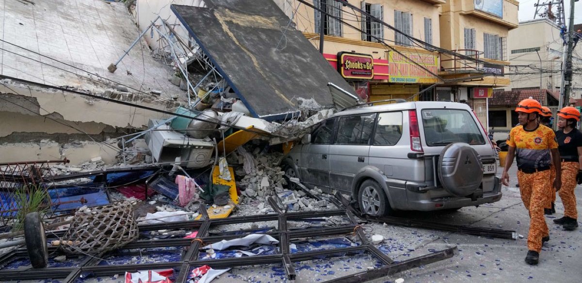
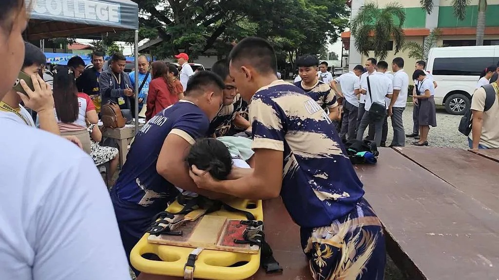
Initial reports confirmed at least seven deaths. In Pantukan town, three miners perished when a gold mine shaft collapsed in the hills west of Manay. One was rescued alive; others were injured. In Mati City, a wall gave way, while two patients at a local hospital suffered fatal heart attacks amid the chaos. In Davao City, debris felled a bystander. Rescue teams continue to comb the wreckage across affected towns.
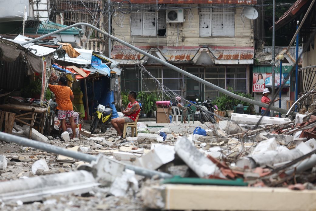
Infrastructure in the area took the brunt of the strain. Power lines snapped. Building foundations cracked. Hospitals, schools, bridges and warehouses sustained damage. Some offices and homes evacuated residents onto sidewalks and open fields. In Manay, all 17 barangays were impacted, and the municipality declared a state of calamity. Authorities suspended classes across the Davao Region, Surigao del Sur, and surrounding provinces. All disaster management offices were placed on red alert, while coastal barangays enacted evacuation protocols.
Video: Earthquake Coverage — Mindanao, Philippines | Courtesy of The Straits Times via YouTube
Short footage of the recent earthquake events. View on YouTube.
Yet these quakes did not strike in isolation. Eleven days earlier, the Philippines suffered a 6.9-magnitude earthquake in Cebu province, the deadliest in the country in over a decade. That quake devastated communities across Cebu island, particularly Bogo and San Remigio, where damages included collapsed churches, hospitals and homes. In total, at least 75 people died and more than 1,200 were injured. The earthquake also triggered countless aftershocks, with over 10,000 tremors recorded in the following days.
Experts see no direct fault link between the Cebu quake and the Mindanao tremors. Cebu lies far to the north, in a different tectonic zone. But the sequence underscores how precarious stability can be in the Philippines.
In the hours after the main quake, tremors continued — more than 300 aftershocks logged across Davao and surrounding areas. Some approached magnitude 5.6, rattling already weakened structures. Officials warned of further collapses and urged residents to avoid unstable buildings.
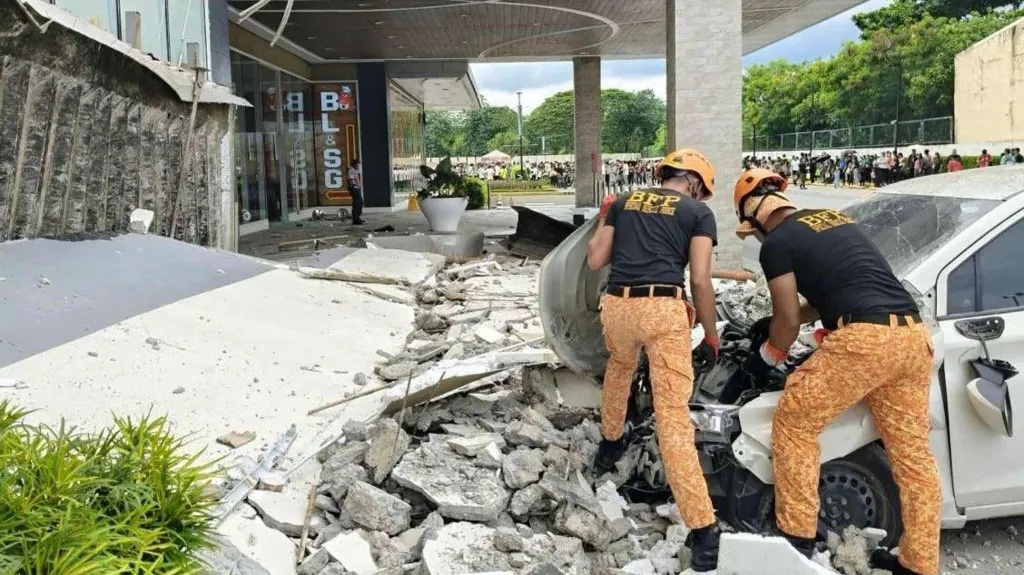
Ground movement was visible in photos and videos: cracks snaked along concrete walls, bridges sagged at joints, and debris littered roadways. In several localities, roofs buckled and masonry facades crumbled. In Tagum City, mid-ceremony events turned chaotic as guests fled. In Compostela, teachers described windows shaking violently, ceilings dusting down. One teacher said it was “the longest few seconds” of her life.
Evacuations remained in effect along vulnerable coastlines. Relief agencies readied supplies, medical teams and search and rescue deployments. The government moved swiftly to mobilize resources, even as communities braced for more aftershocks.
While the Mindanao quakes dominated headlines, seismic tremors continued elsewhere. On October 11, a magnitude 6.0 quake struck just off the coast of Surigao del Sur, about 10 kilometers from Aras-asan town and at a depth of 59 km. No significant damage or casualties were immediately reported. But in a region already strained, the incident heightened anxiety among residents.
The Philippines experiences more than 800 quakes each year. Many are shallow and weak, often unnoticed. But when strong ones strike, the impact is swift and severe. The October 2025 sequence illustrates how multiple quakes in quick succession can multiply damage beyond what a single event would cause.
Mining communities, remote villages, and coastal towns remain especially vulnerable. In Pantukan, for instance, miners who had worked deep underground were trapped when their shafts collapsed. Some tunnels were reported intact, but shifting earth continues to threaten rescue efforts.
The Philippines’ location along converging tectonic plates makes it particularly susceptible to seismic disruption. Two major faults are implicated in the recent quakes: the Philippine Trench and nearby trench systems off Davao. Fault slip in these zones can ripple across broad swaths of Mindanao and the Visayas.
As rescue and assessment enter their next phase, officials warn of continuing tremors, structural fatigue, and aftershock risk. Communities adapt quickly to the threat, but each quake serves as a fresh reminder: in the Philippines, the ground beneath may shift without warning.