A network of lost cities were unearthed in Cambodia


An airbourne laser surveying system called Lidar, an acronym for Light Detection and Ranging, has assisted archaeologists in a project to find previously undocumented cities near Cambodia’s ancient Angkor Wat temple. Using this technology, the most recent project has made discoveries that are rewriting previously conceived notions about Cambodia’s history.
The findings of the project undertaken by Cambodian Archaeological Lidar Initiative (CALI), which were written by Australian archaeologist Dr Damian Evans and recently published in the Journal of Archaeological Science, say the surveying technology revealed a network of lost cities buried under sprawling vegetation.
According to the Smithsonian, the surveyed area of 1901 square kilometres took over 90 hours to find what was previously lost to the jungle. The discoveries made by the project have already significantly expanded knowledge about the scale of the ancient empire, which provides evidence that had previously eluded archaeologists even after the 2012 Lidar survey.
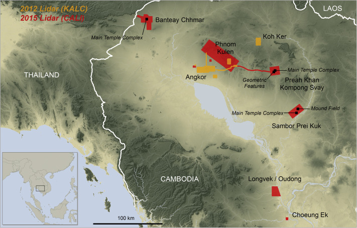
This second Lidar survey, which took place in 2015, allowed Evans and his colleagues at CALI to inspect more ground, uncovering road networks linking settlements, quarries and rivers that had been diverted, according to Discover Magazine. Discover stated that the true size of the site still remains unknown as a result of the decomposition of building materials, such as wood, used by the Khmer empire.
The Guardian has said these hidden cities were densely populated, and with these recent discoveries suggest that, in its height during the 12th century, Angkor would have constituted the largest empire in the world. Dr Damian Evans told The Guardian:
“We have entire cities discovered beneath the forest that no one knew were there – at Preah Khan of Kompong Svay and, it turns out, we uncovered only a part of Mahendraparvata on Phnom Kulen [in the 2012 survey] … this time we got the whole deal and it’s big, the size of Phnom Penh big.”
These discoveries by CALI were only made possible through the use of the technological surveying system Lidar. The system collects data by creating a digital outline of the land’s surface detected by millions of laser points. From a helicopter, the Lidar’s lasers were directed into the Cambodian jungle canopy and over the grounds of Angkor every four seconds, tracing any disparity in the areas terrain.
Here’s a video by Smithsonian to explain how the LIDAR technology works:
Emeritus professor of anthropology at Yale University Michael Coe, who is also a distinguished archaeologist specialising in Angkor and the Khmer civilisation, told The Guardian that “these airborne laser discoveries mark the greatest advance in the past 50 or even 100 years of our knowledge of Angkorian civilisation,”
While Emeritus professor at Monash University in Melbourne, Australia, David Chandler, who has authored several books and articles on Cambodia’s history described the Lidar project as “thrilling”, and told the The Guardian he credits Dr Damian Evans and his colleagues with “rewriting history”.
See Also: Top 8 Things to do in Cambodia
"ExpatGo welcomes and encourages comments, input, and divergent opinions. However, we kindly request that you use suitable language in your comments, and refrain from any sort of personal attack, hate speech, or disparaging rhetoric. Comments not in line with this are subject to removal from the site. "