



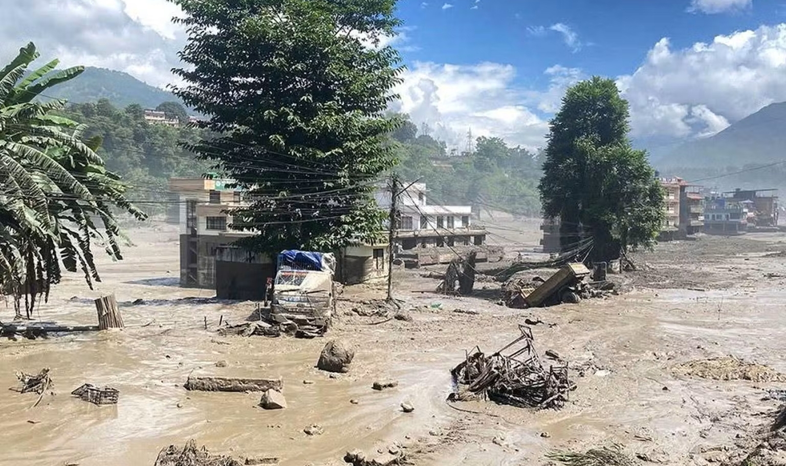
An utterly devastating flash flood tore through Nepal’s Rasuwa district and adjoining areas of Tibet on August 26, obliterating homes, roads, bridges, vehicles, and entire sections of vital infrastructure. With hundreds still unaccounted for, the full scale of the shocking disaster is only beginning to emerge.
One of the inescapable consequences of living in a hyperconnected world, awash in social media, with cameras in every smartphone, and CCTV surveillance covering much of the built environment, is that disasters are increasingly likely to be caught on camera, often from multiple angles and vantage points. There is an uncomfortable voyeuristic side to that phenomenon, yes, but there is also considerable value in the resulting record. Footage captured by residents, travelers, security cameras, dashcams, and other devices can help establish what happened, how things went wrong, and, sometimes, how quickly a disaster unfolded.
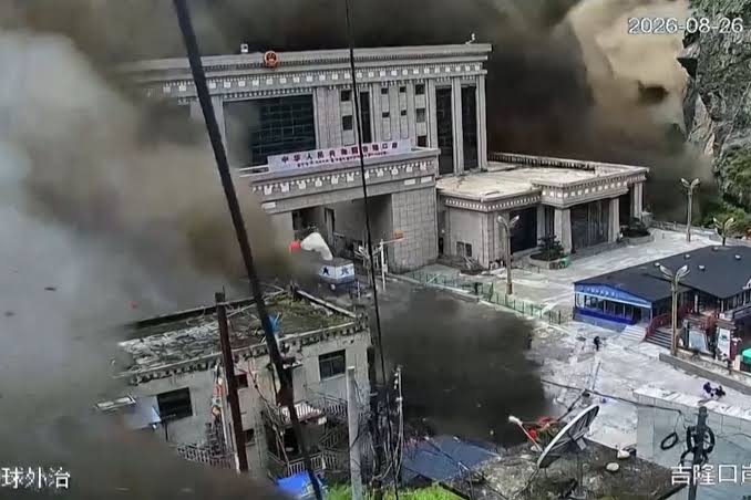
If you have spent any time on social media over the past 24 hours, you have probably seen some of the extraordinary footage emerging from the catastrophic flooding along the Nepal-Tibet border. The images are not only shocking, but difficult to comprehend. An immense torrent of water, mud, ice, and rock tore through settlements and infrastructure with such speed and force that buildings, vehicles, bridges, and other substantial structures simply disappeared, along with scores of people who can be seen fleeing for their lives.
The sheer breadth of the footage is remarkable, too. Videos have emerged from multiple locations and vantage points, including ground-level recordings and aerial surveillance footage, offering a remarkably comprehensive visual record of a disaster in a remote Himalayan region. Some of the coverage is almost cinematic, although there is of course nothing cinematic about the disturbing reality behind those images.
The human toll is already high, and the numbers are all but certain to soar. As of Thursday, Nepalese authorities had recovered 157 bodies, while Chinese authorities reported three deaths on the Tibetan side of the border. Hundreds of people remain missing, and officials expect the official toll to increase sharply as rescue teams gain access to areas that have been cut off by the destruction.
A CATASTROPHE ALONG THE BHOTE KOSHI
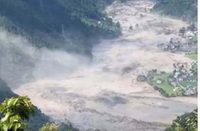
The flooding began on Wednesday morning in Nepal’s Rasuwa district, close to the border crossing at Rasuwagadhi and the Tibetan town of Gyirong. The Bhote Koshi River rose with extraordinary speed at around 9 a.m., sending a destructive surge downstream through steep valleys and into populated areas. As the torrent rampaged down the mountain, it grew in both speed and extent. The result was absolute catastrophic for everything in its path.
The destruction has been extensive. Villages were inundated, roads and bridges were washed away, hydropower facilities were damaged or destroyed, and large quantities of mud and debris were deposited across settlements. Nearly 40 kilometers of road and at least 19 bridges in Nepal have been reported destroyed or swept away.
The consequences extend well beyond the immediate flood zone, as well. The Rasuwa corridor is an important overland route between Nepal and China, as well as a gateway for tourism, business, and pilgrimage. The area is used by travellers heading toward Tibet, including pilgrims traveling to Mount Kailash, while the surrounding valleys are home to hydropower projects, businesses, security and border facilities, and local communities. The destruction is so shocking in its scale, it’s hard to immediately grasp how far-reaching the impact will be.
The timing has also complicated the situation. Large numbers of travelers were in the region, and Nepal’s tourism authorities have been trying to reconcile reports from tour operators. A preliminary list identified 384 travelers as missing, including 291 foreign nationals and 93 Nepalese. The figures have changed as people have been located, while other lists covering workers, security personnel, and local residents have added substantially to the overall number of people unaccounted for.
Among those reported missing are citizens of India, the United States, Australia, Britain, Canada, Malaysia, South Korea, South Africa, and several other countries. Many were heading towards Tibet, while others were working on hydropower projects or trekking in the Rasuwa area.
At least nine South Korean workers at a hydropower project were initially reported missing, while Malaysian authorities said travel agencies had lost contact with 11 Malaysians believed to have been in Rasuwa. The numbers are still being checked against passenger and tour records, so nationality figures should be treated as preliminary.
The rescue operation has involved thousands of Nepalese police, army personnel, and other emergency workers. China’s authorities have mounted a separate operation around Gyirong, where at least three people are confirmed dead and 265 were initially reported missing. Damaged roads, communications failures, power outages, heavy sediment, and continuing instability have all made access difficult.
WHAT ACTUALLY CAUSED IT?
The first reports of the disaster suggested that an earthquake might have triggered the event. That was understandable given the seismic activity detected in the region shortly before the flooding, and the initial U.S. Geological Survey reading classified the event as a magnitude 4.4 earthquake.
Further analysis changed that assessment, though pinpointing the exact cause could take days, or even weeks.
The USGS subsequently concluded that the seismic signal was generated by a landslide rather than an earthquake. Analysis of long-period seismic waves, together with satellite imagery, indicated that a large mass of ice and rock had collapsed in the high Himalayas and entered the Lhende Khola, a river running through the border region.
Exactly what happened next is still being investigated, but the broad sequence is becoming clearer. The ice-rock avalanche entered the river system, producing an enormous surge of water and debris that moved rapidly downstream. The resulting flow was capable of carrying boulders, vehicles, buildings, and other heavy material along with it, which helps explain the extraordinary destruction seen in the videos.
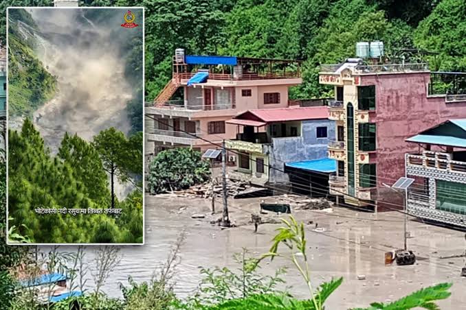
Experts note that it is important to distinguish this event from a conventional monsoon flood. There was apparently little warning in many affected communities because the immediate trigger was a sudden high-altitude collapse rather than hours of steadily rising rainfall-fed river levels. A hydrologist quoted by The Guardian pointed out that the absence of significant rainfall beforehand would have made the event exceptionally difficult for conventional flood-warning systems to anticipate – or for the people who live in this area to reasonably foresee.
There is also evidence of continuing danger. Scientists and authorities have warned that blockages remaining upstream could produce additional flooding if they fail, and residents along the Bhote Koshi, Trishuli, and Narayani river systems have been urged to remain alert and stay away from riverbanks.
The disaster has inevitably and quickly renewed discussion about the changing Himalayan environment. The region is warming, glaciers are retreating, and glacial lakes are expanding in many parts of the Hindu Kush Himalaya. Those changes can increase the likelihood of landslides, ice avalanches, glacial lake outburst floods, and other hazards which exist in high-altitude terrain.
That does not mean climate change can yet be identified as the direct cause of this particular event. Scientists still need to establish precisely why the glacier or slope failed. What is clear is that Himalayan communities are facing a complicated combination of geological and climatic risks, often in places where there is limited infrastructure and little margin for error.
A RACE AGAINST TIME
For Nepal, the immediate and obvious priority is finding people who remain missing and reaching communities cut off by the destruction. More than 3,300 police personnel have reportedly been deployed, alongside military and other rescue teams, while helicopters are being used where weather and terrain permit. International assistance is also being mobilized, including support from India, China, the United Nations, the World Health Organization, and other agencies.
The geography makes the task particularly difficult. In some places, roads have entirely vanished, bridges have been swept downstream, and thick layers of sediment and debris have buried buildings and vehicles. In some areas, rescue teams are effectively working their way into a landscape that has been physically rearranged by the violent flood.
The destruction on the Tibetan side is similarly harrowing. Chinese authorities have reported extensive damage around the Gyirong border crossing, with roads, buildings, power infrastructure, and other facilities affected. President Xi Jinping has called for an intensive search for those missing and for stronger monitoring and early-warning measures to reduce the risk of further disasters.
For families and others waiting for news, the painful uncertainty is compounded by the fact that the various lists of missing people are still being reconciled. Some people reported missing by tour operators have subsequently been located, while others have been added to official lists as communications are restored and authorities establish who was in the affected areas, and when.
The disaster is also a reminder of the particular vulnerability of the Himalayan road and river corridors. Economic development has brought roads, bridges, hydropower facilities, tourism infrastructure, and increasingly busy trade routes into valleys where the underlying terrain remains extraordinarily dynamic, and as this disaster shows, dangerous, as well.
It’s not the first incident of this nature, either. A similar flood struck the broader Bhote Koshi area in 2025, also associated with a high-altitude glacial event. The recurrence has added urgency to calls for better monitoring of glaciers and unstable slopes, more effective warning systems, and greater protection for communities and infrastructure downstream.
For now, however, the scale of the August 26 disaster is still being established. The confirmed death toll of at least 160 on both sides of the border is almost certainly not the final figure, and many hundreds remain unaccounted for. With access to some of the worst-hit areas still severely restricted, the full extent of the loss may not become apparent for days.
Sources: Reuters, Associated Press, The Guardian, Financial Times, U.S. Geological Survey (USGS), Nepalese authorities, Nepal Tourism Board, and International Centre for Integrated Mountain Development (ICIMOD).