


A powerful magnitude 7.8 earthquake struck off the southern Philippines on June 8, leaving widespread destruction across Mindanao and briefly triggering tsunami warnings that extended as far as Sabah’s east coast.
The southern Philippines was rocked by one of its strongest earthquakes in recent years on the morning of June 8, when a magnitude 7.8 tremor struck just off the coast of Sarangani province in Mindanao, causing significant damage, loss of life, and widespread panic across the region.
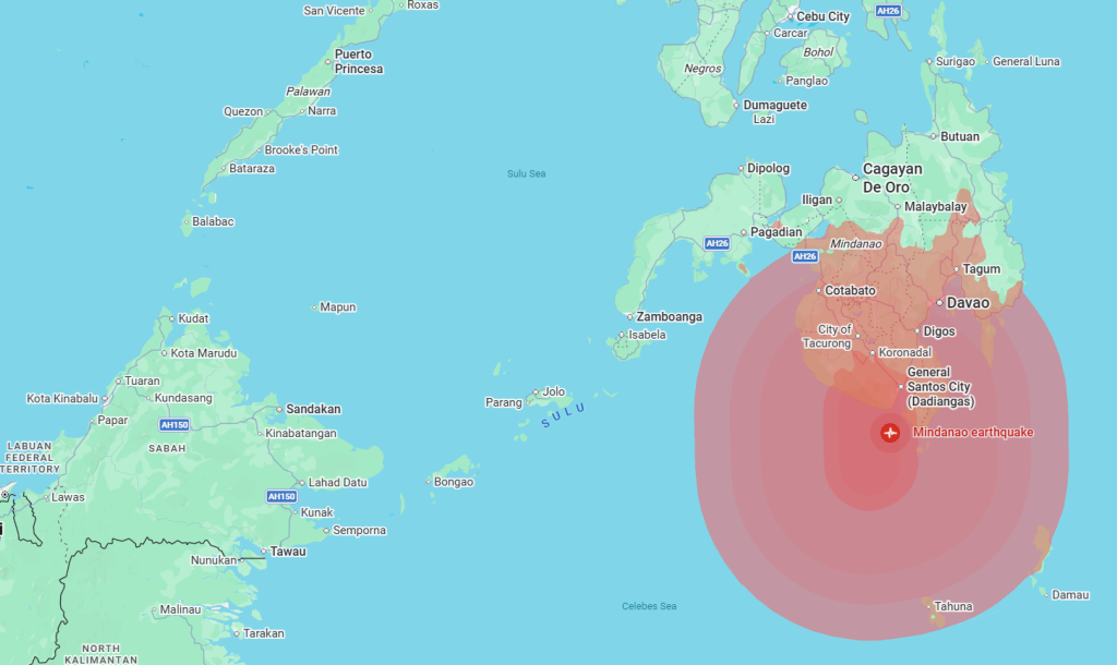
The offshore quake, which occurred at approximately 7.37am local time, was centred near General Santos City at a relatively shallow depth, amplifying its impact across much of Mindanao. Initial measurements varied among international monitoring agencies before the magnitude was ultimately revised upward to 7.8 by Philippine authorities.
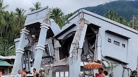
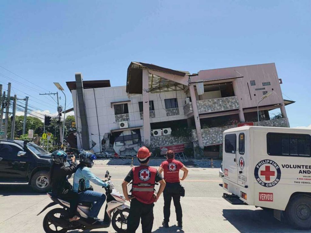
As of late Monday, authorities were continuing to verify casualty figures, with reports indicating that at least 19 people had died and more than 130 had been injured, though some local reports suggested the toll could rise as rescue teams reached badly affected communities. By late afternoon, news agencies including the Associated Press and Reuters were reporting a toll of at least 32.
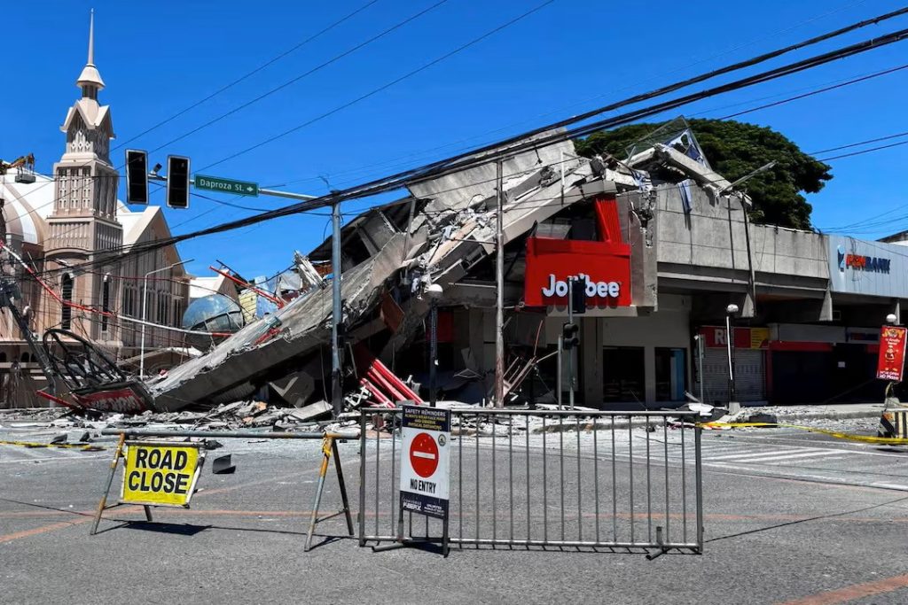
Many of the casualties were attributed to collapsing structures, falling debris, and landslides triggered by the violent shaking. Video footage circulating online showed the collapse of a commercial building housing a fast-food restaurant in General Santos City, while damage was also reported at educational institutions, hospitals, and residential areas.

For many Malaysians, particularly those in East Malaysia, the earthquake was more than simply a regional news story. The quake prompted tsunami advisories that of course extended across international borders, including parts of Indonesia, Japan, and Sabah. For many in the region, the scars of the 2004 Boxing Day tsunami are still fresh, despite happening over two decades ago. The massive tsunami, generated by one of the most powerful undersea quakes in recorded history, devastated large swathes of the region and claimed nearly 230,000 lives.
Authorities in Sabah quickly activated precautionary measures for coastal districts including Tawau, Semporna, Kunak, and Lahad Datu, where residents were advised to move away from shorelines and remain alert for possible tsunami activity. MetMalaysia forecast waves of up to 0.4 metres for parts of the east coast before the advisory was officially lifted around midday after monitoring confirmed that no dangerous tsunami had materialized.
The proximity of the epicentre to Sabah underscores just how closely linked the region’s geological risks can be. Sarangani lies only a few hundred kilometres from the eastern coast of Borneo, and while strong tremors were not widely reported in Malaysia, the event once again highlighted the importance of regional early-warning systems and cross-border disaster coordination.
A REGION ON EDGE
The Philippine Institute of Volcanology and Seismology (PHIVOLCS) initially issued a tsunami warning for several coastal provinces, cautioning that waves exceeding one metre above normal tide levels could affect vulnerable shorelines, bays, and straits. Residents in affected areas were ordered to evacuate immediately to higher ground, while fishing vessels already at sea were advised to remain in deeper waters until the threat had passed.
Fortunately, sea level monitoring later indicated that the resulting tsunami waves were relatively small, allowing authorities to cancel the warning several hours after the earthquake.
Philippine President Ferdinand Marcos Jr. ordered an immediate national response, directing disaster management agencies, military units, and local governments to mobilize rescue and relief operations across Mindanao.
“The national government is moving and we will not leave Mindanao behind,” the president said, while also urging residents in coastal communities to heed official evacuation instructions.
One witness, Moe Z, described the aftermath in stark terms after arriving near the blast zone.
“Everything was completely destroyed beyond recognition,” he said, recalling how a towering column of smoke rose into the sky immediately after the quake struck. According to his account, many initially believed the area had come under air attack because of the sheer force of the explosion-like impact.
Officials also reported more than 200 aftershocks throughout the day, with several registering above magnitude 6.0. The strongest reached magnitude 6.7, adding to fears among residents and complicating rescue efforts as emergency crews worked around unstable structures.
Watch the Earthquake Footage
Dramatic video shared on Instagram shows the powerful shaking and a building collapse in the June 8 Mindanao earthquake, with workers running to safety just seconds before the collapse.
▶ View Instagram ReelOpens in Instagram. You may need to be logged in to view the content.
THE PACIFIC RING OF FIRE
Malaysia is incredibly fortunate when it comes to natural disasters, but plenty of ASEAN is not quite so lucky. Earthquakes are a frequent reality for both the Philippines and other parts of Southeast Asia (most notably Indonesia) because of their location along the Pacific Ring of Fire, one of the world’s most active seismic zones. The vast tectonic belt stretches around the Pacific Ocean and is responsible for roughly 90% of the world’s earthquakes.
The Philippines experiences hundreds of measurable earthquakes every year, though only a fraction cause significant damage. Nevertheless, powerful events such as the June 8 quake serve as a reminder of the constant geological forces at work beneath the region.
For Malaysia, particularly Sabah and Sarawak, large offshore earthquakes in neighbouring countries can occasionally create secondary risks, most notably tsunami threats. Although the 2026 Mindanao event today ultimately produced only minor sea level changes, the swift response by Malaysian authorities demonstrated the importance of preparedness.
As damage assessments continue across Mindanao, emergency crews remain focused on locating survivors, restoring essential services, and helping affected communities begin the long recovery process. With aftershocks expected to continue for days, authorities have urged residents to remain vigilant and avoid entering damaged buildings until they have been declared safe.
Sources: Reuters; Associated Press; GMA News; MetMalaysia; PHIVOLCS; New Straits Times; The Star.